PRESTON
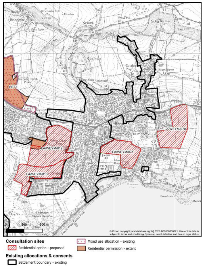
Preston is a village and suburb on the eastern edge of Weymouth, just a few miles from the town centre. It lies within the Littlemoor & Preston ward of Dorset Council.
With its mix of residential areas, green space and coastal proximity, Preston retains a semi-rural feel while being connected to the wider Weymouth area. The community includes local schools, a village hall and key services, but also faces pressure from growth, infrastructure demand and changing land use.
On this page you’ll find how the proposed sites under the Dorset Local Plan affect Preston, what’s being proposed, what could change, and how you can respond.
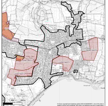
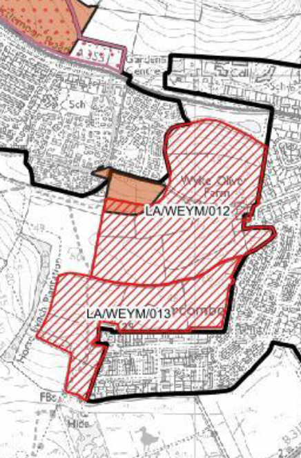
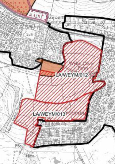
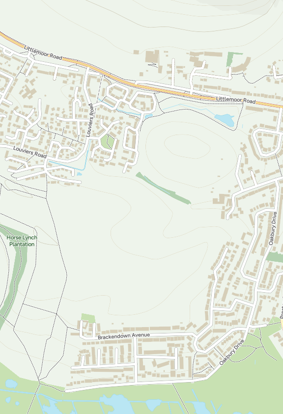
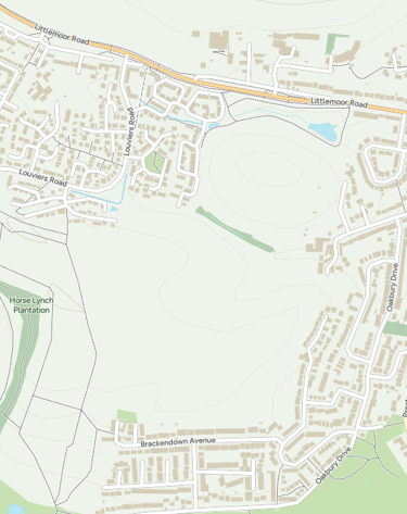
LA/WEYM/012 – Wyke Oliver Farm North
Wyke Oliver Farm North is one of the largest proposed development sites in the Weymouth area, positioned between Littlemoor and Preston on farmland that slopes down towards the Lorton Valley. Dorset Council lists the site as capable of delivering around 554 homes together with open space and a potential extension to the Lorton Valley Nature Park. The land is currently open countryside, crossed by hedgerows and drainage channels and bordered by Wyke Oliver Road to the west.
The council’s own assessment recognises that the site sits in an elevated position and that parts of it are prone to surface-water run-off. It forms part of the catchment feeding the springs and streams that eventually flow through the Lorton Valley and Lodmoor wetlands. The slope, combined with heavy clay soils, already causes flooding at points on Wyke Oliver Road and adjoining properties. Residents have long argued that large-scale building here would worsen drainage and traffic conditions, and that road access is poor for a site of this scale.
This land also frames the visual approach to Weymouth from the east. Development on such a prominent hillside would be visible from the AONB ridges above Preston and from across the Lorton Valley, potentially eroding the town’s green setting. Public footpaths run through and around the fields, linking to the Nature Park and countryside beyond.
When writing your response, refer to the relevant NPPF paragraphs, 176 to 182 for landscape and AONB, 167 for flood risk, 179 to 182 for biodiversity and 111 for transport. Linking your comments to these policy references ensures they are considered as soundness matters during the plan’s examination.
My good friend Glenn has written extensively about Wyke Oliver Farm North on his own community website, offering a detailed look at the site, the evidence, and the wider implications for Weymouth’s future growth.
You can read his full analysis here: 👉 Weymouth Neighbourhood Plan Democracy – Wyke Oliver Farm North


Under the National Planning Policy Framework (NPPF), several key policies apply: Paragraphs 176–182 require local authorities to give great weight to conserving landscape character and scenic beauty, particularly where development affects the setting of an Area of Outstanding Natural Beauty. Paragraph 167 requires a sequential approach to flood risk, steering housing to lower-risk land wherever possible. Paragraphs 179–182 expect councils to protect and enhance ecological networks and deliver at least 10 per cent Biodiversity Net Gain (BNG), a measurable improvement in wildlife habitat secured for at least 30 years. Paragraph 111 states that development should be refused where the impact on the road network would be severe.
When commenting on this site, you may wish to:
ask the council to publish a full flood-risk assessment and drainage strategy, including how surface water from new roofs and roads will be managed before it reaches Wyke Oliver Road;
request a landscape and visual-impact assessment showing how development would affect views from the Lorton Valley and the AONB hills;
seek a biodiversity and green-corridor plan that proves a 10 % net gain can be achieved on-site and that the existing ecological connections to the meadow are maintained;
call for an independent transport assessment covering access, traffic flow and pedestrian safety on Wyke Oliver Road and Preston Road;
and ask that archaeological and heritage features, if any, are recorded and preserved before allocation.
LA/WEYM/013 – Wyke Oliver Farm South
This site sits on open farmland south of Wyke Oliver Road, on the slope that drops down towards Preston. Dorset Council is proposing about 225 homes here on roughly 19 hectares of greenfield land. The fields are visible from the Lorton Valley and from the AONB ridge above Littlemoor, forming part of the green gap that currently separates Weymouth from the countryside.
The council’s own documents recognise that the land is environmentally sensitive. It borders Dorset Wildlife Trust’s reserve and connects directly into the Lodmoor Site of Special Scientific Interest (SSSI), lying within an identified wildlife corridor. The northern edge is elevated and prominent, with clear views from the National Landscape. The assessment says any development would need to respect local character, retain hedgerows, and provide generous buffers to protect habitats. Drainage is another key issue, a flood-risk assessment is required, as parts of the land already experience surface-water problems. Vehicle access would depend on new links to Wyke Oliver Close, along with improved footways and cycle connections.

Under the National Planning Policy Framework (NPPF), development here must be judged against several national tests. Paragraphs 176 to 182 require councils to give great weight to conserving and enhancing the landscape and scenic beauty of Areas of Outstanding Natural Beauty, allowing major development only in exceptional circumstances and where it is clearly in the public interest. Paragraphs 179 to 182 stress that plans must protect existing ecological networks and deliver at least a 10 per cent Biodiversity Net Gain (BNG), secured for 30 years. Paragraph 167 sets out the requirement to steer new housing away from flood-risk areas and prove that any surface-water discharge can be managed safely. Paragraph 111 states that permission should be refused if cumulative transport effects would be severe. Together, these policies make clear that landscape, drainage, ecology and access all have to be demonstrated before this site can be considered sound.
When commenting on this site, you may wish to:
ask Dorset Council to publish a full Landscape and Visual Impact Assessment before allocation, explaining how the proposal meets the "exceptional circumstances" test for building beside the AONB.
request a detailed Biodiversity Net Gain plan showing how the 10 per cent gain will be achieved on or next to the site, with mapped wildlife corridors and long-term management.
seek a comprehensive Flood-Risk Assessment and sustainable-drainage strategy so that surface water does not add to problems further downhill.
call for an independent transport study that looks at safe access to Wyke Oliver Close and Preston Road, pedestrian safety, and bus links to Weymouth and Littlemoor.
point out the cumulative impact; when added to Wyke Oliver North (WEYM/012), Beverley Road (WEYM/003) and the Littlemoor/Bincombe sites, this stretch of Weymouth faces hundreds of new houses without matching infrastructure.
When writing your response, refer to the relevant NPPF paragraphs above. Linking your comments to these policy tests ensures they are treated as a soundness issue that the planning inspector must consider.
My good friend Glenn has written extensively about Wyke Oliver Farm South on his community website, well worth a read for anyone wanting to understand the background in more detail: 👉 Weymouth Neighbourhood Plan Democracy – Wyke Oliver Farm South
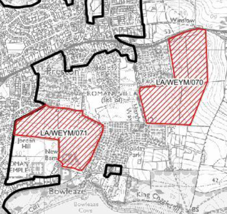

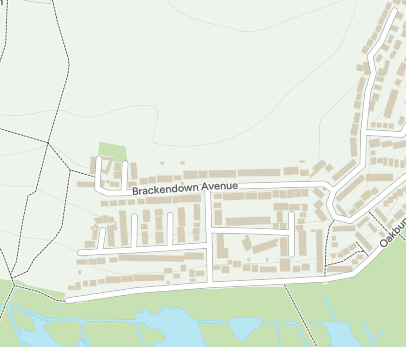
LA/WEYM/070 – Land South of Coombe Valley Road
This site sits on the south-facing slope between Coombe Valley Road and Southdown Farm, on the western edge of Preston. Dorset Council identifies it as an area of search for around 361 homes. It’s currently open grassland with scattered trees and hedgerows that mark the transition from the built-up suburbs of Weymouth to the rural fields of the Lorton Valley.
Council mapping shows part of the land falls within a surface-water flood-risk zone that feeds into the nearby Coombe Valley stream. The gradient means any development here could push run-off downhill toward existing housing and road drains. The approach roads, particularly Coombe Valley Road and Southdown Avenue, are narrow and already under pressure from on-street parking. Access design and pedestrian safety are therefore central issues.
The area also borders a local wildlife corridor linking to the Lodmoor and Lorton nature sites. Hedgerows and field margins provide habitat for bats and birds and should be retained. The site is visually open in places and visible from the Dorset Area of Outstanding Natural Beauty (AONB) ridge, so layout and building height will be key in keeping the landscape character.
Under the National Planning Policy Framework (NPPF), the proposal must satisfy several national policies. Paragraphs 176–182 require great weight to be given to conserving and enhancing scenic beauty in AONBs and their settings, with major development allowed only in exceptional circumstances. Paragraph 167 requires councils to apply the sequential test for flood risk and prove that drainage can be handled safely through sustainable-drainage systems. Paragraphs 179–182 require protection of ecological networks and delivery of a measurable 10 per cent Biodiversity Net Gain (BNG) that is secured for at least 30 years. Paragraph 111 demands refusal where the cumulative traffic impacts would be severe. Together these tests mean the Council must show that the site can be drained, accessed, landscaped and made biodiversity-positive without harming its setting or overloading local roads.
When commenting on this site, you may wish to:
ask the Council to provide a full flood-risk and drainage strategy, including Sustainable Drainage Systems design and proof that downhill properties will not face additional run-off.
request a landscape and visual-impact assessment demonstrating how views from the AONB ridge and nearby public rights of way will be protected.
seek a clear Biodiversity Net Gain plan that shows where and how the 10 per cent improvement will be achieved, with permanent hedgerow and wildlife-corridor buffers.
call for a detailed transport assessment covering junction safety, parking pressure on Coombe Valley Road, and safe walking routes to schools, shops and bus stops.
point out that the cumulative effect of this site, when combined with Wyke Oliver Farm South (WEYM/013) and Budmouth Avenue (WEYM/012), will add significant traffic and service demand across Preston without corresponding investment.
When writing your response, reference the relevant NPPF paragraphs above, 167 for flood risk, 176 to 182 for AONB and landscape, 179 to 182 for biodiversity, and 111 for transport, to ensure your comments are treated as soundness issues at examination.
LA/WEYM/071 – Land at Coombe Valley Road (West)
This site lies on the western side of Coombe Valley Road, just south of Preston Road, forming part of the open slope that leads down toward Lodmoor and the Coombe Valley stream. Dorset Council lists it as an “area of search” for roughly 316 homes. The land is mostly grassed pasture with a line of hedgerows and mature trees, and from the upper ground you can see across to the Lorton Valley and the AONB ridgeline.
It’s another visibly semi-rural parcel that helps separate Weymouth’s eastern suburbs from the lower valley landscape. The Council’s notes highlight the need to protect the wildlife corridor that follows the stream and hedgerows, as well as to address surface-water flooding, the slope directs run-off towards existing housing along Coombe Valley Road. The narrowness of the road, combined with parking and bus movements, already limits capacity. Access design and footway improvements will be essential if any development proceeds.


Under the National Planning Policy Framework (NPPF), this proposal must meet several key policy tests. Paragraphs 176 to 182 require great weight to be given to conserving and enhancing the Area of Outstanding Natural Beauty (AONB) and its setting; any major development nearby must demonstrate exceptional circumstances and a clear public interest. Paragraph 167 requires councils to apply the sequential test for flood risk and prove that sustainable-drainage measures can contain run-off on-site. Paragraphs 179 to 182 commit planning authorities to protect ecological networks and deliver at least 10 per cent Biodiversity Net Gain (BNG), managed for 30 years. Paragraph 111 makes clear that development should be refused if cumulative transport effects are severe.


When commenting on this site, you may wish to:
ask Dorset Council to publish a flood-risk and surface-water assessment, showing how rainfall from the slope will be controlled before it reaches Coombe Valley Road and nearby homes.
request a full landscape and visual-impact assessment demonstrating how development would avoid harming the AONB setting and the green gap between Weymouth and the valley floor.
seek a Biodiversity Net Gain plan detailing how hedgerows, trees and the Coombe Valley wildlife corridor will be protected and enhanced to achieve the required 10 per cent gain.
call for a transport and access study that examines road capacity, on-street parking, visibility splays and safe pedestrian routes to Preston Road and local schools.
raise the cumulative impact issue: together with neighbouring allocations at Wyke Oliver Farm South (WEYM/013), Wyke Oliver Farm North (WEYM/012) and Coombe Valley East (WEYM/070), this cluster of sites could significantly increase traffic, drainage and service pressures in Preston.
When writing your response, refer to the relevant NPPF paragraphs, 167 (flood risk), 176 to 182 (AONB and landscape), 179 to 182 (biodiversity and BNG) and 111 (transport). Linking your points to these policies ensures they are treated as soundness issues at the plan examination.