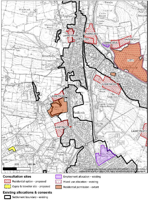
BINCOMBE
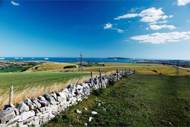
Bincombe is a small semi-rural village on the northern edge of Weymouth, lying directly north of Littlemoor on the slopes above the Coombe Valley. It sits along the A354 route between Weymouth and Dorchester, offering wide views over the Dorset countryside and down towards the coast.
Although close to the town, Bincombe still feels distinct, a cluster of homes and farms surrounded by open fields, chalk downland and old hedgerows. The 13th-century Holy Trinity Church marks its historic heart, and footpaths lead out across the ridge, connecting to the South Dorset Ridgeway and the wider Dorset AONB.
Most of the potential development identified in the Dorset Local Plan lies on Bincombe’s southern slopes, between the existing village and Littlemoor. This area forms part of the green gap that currently separates the town from the countryside. How these southern fields are treated will decide whether Bincombe remains a distinct village or becomes absorbed into Weymouth’s northern expansion.


LA/BINC/001 – 8 Acre Field, Icen Lane
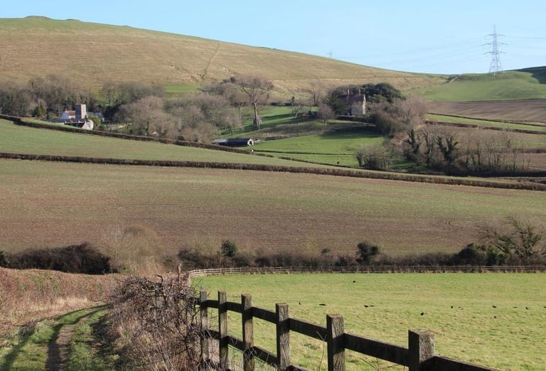
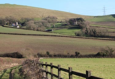
This site lies on the southern edge of Bincombe, just north of Littlemoor, on open farmland known locally as 8 Acre Field. Dorset Council lists it for about 63 homes on roughly 2.9 hectares of greenfield land. It sits inside the Dorset National Landscape (AONB) and forms part of the visible northern ridge above Weymouth.
According to the council’s own assessment, the field is enclosed by established hedgerows with a small stream or surface-water ditch on its eastern edge. It falls gently towards Icen Lane and links visually with the adjoining sites to the north and east. The assessment identifies several constraints: the land is classed as major development in the AONB, meaning any building would need exceptional circumstances and a proven public interest; there is a strip of surface-water flood risk along the lower boundary; and any access would require new vehicular, pedestrian and cycle connections along Icen Lane, plus school-place provision. It also notes that development here should not be considered in isolation, because together with the nearby Bincombe sites it forms part of a wider pattern of expansion north of Littlemoor.
LA/BINC/002 – Land north of Icen Lane (site 1)
Greenfield land (listed for 108 homes) on the north side of Icen Lane, between the A354 and the railway. Dorset Council’s own assessment flags several constraints: hedgerows that act as habitat, a wildlife corridor along the rail line, and the fact the site (with BINC/003) sits within the Dorset National Landscape (AONB). There are pockets of moderate–high surface-water flood risk on the western edge (near "Bunnies Leap") and in the south-east corner, so a site-specific flood-risk assessment is required and any build area should avoid those strips. Noise is a consideration (A354 to the east, railway to the west). Public rights of way cross or run beside the site; access will need proper vehicular, pedestrian and cycle links to Icen Lane, with potential passing places and footway upgrades, and Dorset Council even suggests managing traffic flow under the Old Station Road bridge. Delivery is expected to be co-ordinated with BINC/003; a contaminated-land desktop study is advised due to rail-adjacent risks. Pre-determination archaeology is also requested because of cropmark evidence.
Under the National Planning Policy Framework (NPPF), the same key policies apply here. Paragraphs 176 to 182 require great weight to be given to conserving and enhancing the scenic beauty of the AONB; major development is allowed only in exceptional circumstances and where it clearly serves the public interest. Paragraph 167 calls for a sequential approach to flood risk and for surface-water run-off to be contained within the site. Paragraphs 179 to 182 require the protection and enhancement of biodiversity corridors and at least a 10 per cent Biodiversity Net Gain (BNG). Paragraph 111 directs that development should be refused where residual transport impacts would be severe. Together, these principles mean the council must prove this small parcel can be safely accessed, drained and landscaped without undermining the wider AONB setting.
When commenting on this site, you may wish to:
ask for a joint master-plan with BINC/002 showing how both parcels will share access, drainage and green infrastructure rather than being treated piecemeal;
request a Landscape and Visual Impact Assessment explaining how development here meets the AONB "exceptional circumstances" and “public interest” tests;
seek a clear BNG delivery plan, mapping the railway wildlife corridor and specifying buffers, habitat creation and long-term management for at least 30 years;
call for a transport statement demonstrating that Icen Lane can safely accommodate extra traffic, with new footways, passing places and cycle links to Littlemoor;
ask for noise and surface-water assessments, ensuring design mitigation before allocation, not after planning permission.
When writing your response, refer to the relevant NPPF paragraphs, 176 to 182 (landscape and AONB), 167 (flood risk), 179 to 182 (biodiversity and BNG) and 111 (transport and access). Citing these sections ensures your comment is treated as a soundness issue that the Planning Inspector must consider at examination.
LA/BINC/004 – The Willows
This is a greenfield parcel on the southern edge of Bincombe, just north-east of Littlemoor. Dorset Council estimates ~57 homes on about 3.18 ha. The land sits inside the Dorset National Landscape (AONB) and is enclosed by mature hedgerows. The council’s assessment flags the edge-of-settlement setting, potential cumulative impacts with the Littlemoor Urban Extension, and the need to plan this site alongside LA/BINC/001 so access, drainage and green infrastructure work as a single scheme. Modest pockets of low surface-water risk occur along the Icen Lane frontage. Vehicular, pedestrian and cycle access would be taken from Icen Lane, likely needing footway and passing-place upgrades, with a full Transport Assessment. School-place pressure is also noted. There are no known designated heritage assets on or near the site.
Under the National Planning Policy Framework, proposals here have to clear several national tests. For AONB/landscape, decision-makers must give great weight to conserving and enhancing scenic beauty; major development in or affecting an AONB needs exceptional circumstances and a clear public interest case (paras 176–182). For flood risk, plans should apply the sequential approach, keep homes out of the mapped risk strips, and show how run-off will be managed over the development’s lifetime (para 167). For biodiversity, ecological networks such as the railside corridor and hedgerows should be protected and enhanced, and the scheme must deliver a minimum 10% Biodiversity Net Gain secured for 30 years (paras 179–182). On movement and access, development should only proceed where safe, suitable access is demonstrated and where residual cumulative impacts are not severe (para 111). Remember to use these paragraph numbers in your response.
When commenting on this site, you may wish to:
ask Dorset Council to publish an AONB/landscape case up front (Landscape and Visual Impact Assessment plus an alternatives analysis) explaining why development in this sensitive location is justified and how harm will be limited;
request a flood-risk and drainage strategy that keeps building out of the high-risk pockets and proves where surface water will safely discharge after winter groundwater monitoring;
seek a biodiversity and BNG plan that maps the rail-side wildlife corridor and hedgerow buffers, shows how 10% net gain will be achieved on or next to the site, and commits to long-term management;
call for an access and movement package before allocation: Icen Lane footway creation, passing places, visibility splays, and evidence that traffic under Old Station Road bridge can be managed safely; retain and improve the public rights of way;
ask for noise and contamination assessments (rail and A354) with any required mitigation embedded in the site layout; require pre-determination archaeology;
insist on co-ordinated master-planning with BINC/003 so drainage, access, landscape buffers and active-travel links are designed as one.
Under the National Planning Policy Framework (NPPF), this proposal engages several key principles. Paragraphs 176 to 182 require councils to give great weight to conserving and enhancing the scenic beauty of Areas of Outstanding Natural Beauty, permitting major development only in exceptional circumstances and where it clearly serves the public interest. Paragraph 167 sets out the need for a sequential approach to flood risk, steering housing to lower-risk land and showing how any run-off will be safely managed. Paragraphs 179 to 182 call for the protection and enhancement of biodiversity networks and delivery of a minimum 10 per cent Biodiversity Net Gain (BNG), secured for 30 years. Paragraphs 110 to 113 stress that development should provide safe, suitable access for all users and be refused if residual road impacts would be severe.
When commenting on this site, you may wish to:
ask the council to publish a full Landscape and Visual Impact Assessment explaining how the scheme meets the “exceptional circumstances” and "public interest" tests for AONB development;
request a detailed flood-risk and drainage plan, showing how surface water will be managed and how the flood-risk strip along the eastern edge will be protected as green space;
seek a clear Biodiversity Net Gain strategy, mapping retained hedgerows and buffer zones, and explaining how a 10 per cent gain will be achieved on-site;
call for a safe-access and transport plan covering Icen Lane improvements, passing places, footway extensions, and realistic walking links to Littlemoor services;
ask for an assessment of the combined impact of all Bincombe allocations (BINC 001–004) to show whether local roads, schools and drainage systems can cope with the total growth proposed.
When writing your response, refer to the relevant NPPF paragraphs above, 176 to 182 for landscape, 167 for flood risk, 179 to 182 for biodiversity, and 110 to 113 for transport. so your comment is treated as a soundness issue that must be considered at examination.


LA/BINC/003 – Land north of Icen Lane (site 2)
A small parcel of greenfield land north of Icen Lane, immediately beside site 002. Dorset Council estimates around 41 homes here, on a gently sloping field bordered by hedgerows and the railway corridor. The site sits wholly within the Dorset National Landscape (AONB) and shares many of the same sensitivities as its larger neighbour: exposure in long views, the ecological function of the rail embankment, and the narrow rural form of Icen Lane.
The council’s own assessment stresses that development should be delivered jointly with BINC/002 so drainage, access and layout are consistent. It highlights the need to retain existing hedgerows, protect the railway wildlife corridor, and improve pedestrian and cycle links to Icen Lane. A transport statement is required to demonstrate safe access, while noise from the railway and traffic must be considered at design stage. Surface-water management and flood-risk assessment will also be needed.

Under the National Planning Policy Framework (NPPF), proposals here have to satisfy several national tests. Decision-makers must give great weight to conserving and enhancing the scenic beauty of AONBs; “major development” should only proceed in exceptional circumstances and where it is clearly in the public interest (paras 176–182). The plan must also protect ecological networks and deliver at least 10% Biodiversity Net Gain (BNG) secured for 30 years (paras 179–182). Any flood-risk and run-off issues require a sequential approach and a site-specific strategy (para 167). On transport, development should be refused if residual cumulative impacts on the road network would be severe and safe, suitable access for all users cannot be demonstrated (para 111). Taken together, that means landscape, ecology/BNG, drainage and a realistic Icen Lane access package all need to be evidenced upfront, not left to later.
When commenting on this site, you may wish to:
ask the council to publish a Landscape & Visual Impact Assessment and an AONB “exceptional circumstances” case, showing why this edge-of-settlement AONB location is justified over less sensitive alternatives;
request a joint masterplan with LA/BINC/001 that coordinates street layout, hedgerow buffers, SuDS and walking/cycling links, so the two sites don’t come forward piecemeal;
seek a BNG delivery plan mapping retained/enhanced hedgerows and wildlife buffers, and proving how the 10% net gain will be achieved and managed long-term;
call for a site-specific flood-risk/SuDS strategy (including winter groundwater monitoring) and for any low-risk strips on the Icen Lane edge to be kept as green space;
require an Icen Lane access package before allocation: visibility, passing places, new footway, cycle connections to existing routes, and a Transport Assessment testing cumulative growth with BINC/001 and Littlemoor;
ask how school-place needs will be funded and delivered in time with the build-out.
When writing your response, refer to the relevant NPPF paragraphs, 176–182 (AONB and landscape), 179–182 (biodiversity and BNG), 167 (flood risk and drainage), and 111 (transport and access). Quoting these turns your points into soundness issues the Inspector must consider.